How To Use .KMZ Data When Evaluating Fiber Routing Options for DIA / WAN
If you’re designing a wide area network (WAN), you’ll need to know about .kmz files. We’ll unpack how to use .kmz files to guide your connectivity procurement.
Jun 7, 2023
SHARE
Automate the telecom lifecycle
Get better quotes, launch sites faster, keep inventory accurate, and control spend.
If you’re designing a resilient wide area network (WAN) for your business, you’ll need to know about .kmz files. We’ll unpack how to use .kmz files to guide your decision-making when procuring fiber-based WAN connectivity.
What Is .KMZ?
Basically, a .kmz file is a map. A Keyhole Markup Language (.kml) file contains map information you can read with a GIS tool such as Google Earth. The “z” in .kmz stands for “zipped,” which means the file has been compressed, and may also contain additional data or overlays for the map.
Why Is .KMZ Data Useful When Procuring WAN Connectivity?
When you’re talking to multiple fiber vendors and preparing to design your enterprise network, asking them to send you .kmz files outlining the physical route of their fiber will allow you to optimize your network for carrier and route diversity.
Let’s take a hypothetical example – Jeff’s investment management.
Jeff has an established data-center presence in Orlando, Florida. We’ll refer to this as the A LOC (location A), which we’ll think of as the carrier location at the edge of Jeff’s network.
Jeff’s setting up a new site in Miami. We’ll call this the Z LOC (location Z), which on our new network would be classed as the end user.
Jeff’s managing a high-profile hedge fund. He can’t afford to lose connectivity at any point. The financial implications if he can’t monitor and respond in real-time to events could be significant. Jeff needs at least two redundant carriers with as much diversity in their physical fiber routes as possible.
Sourcing carriers to provide the high level of service Jeff requires shouldn’t be a problem (especially using Lightyear’s automated telecom procurement platform). The tricky bit is ensuring that their fiber routes are actually diverse.
Continuously optimize your network
How To Use .KMZ Data for Network Diversity
Step 1 – Research the service area to uncover the right carriers in your new location.
Step 2 – Reach out to viable carriers and ask them for a quote. (or use Lightyear to skip steps 1-2)
Step 3 – After reviewing your options, choose the company with the best quote to be your primary carrier. You know your criteria for choosing the best quote – chances are, it’s the usual factors, like pricing, level of guaranteed service in the SLA, reputation, and so on.
Step 4 – Ask your preferred carrier to provide a .kmz file for the fiber route they’d use to connect your A LOC and Z LOC. This fiber route, by default, becomes the primary route.
Step 5 – Select several of the other carriers and ask them for their .kmz files (obviously, steps 3 through 5 can be carried out simultaneously).
Step 6 – Using a GIS tool such as Google Earth, open the .kmz files and examine which combination of carriers will provide the greatest diversity.
So, what would a .kmz file typically look like? Let’s go through some examples here (but please note these images aren’t genuine fiber routes – carriers don’t readily share this information, and usually ask you to sign an NDA before they’ll send you a .kmz file).
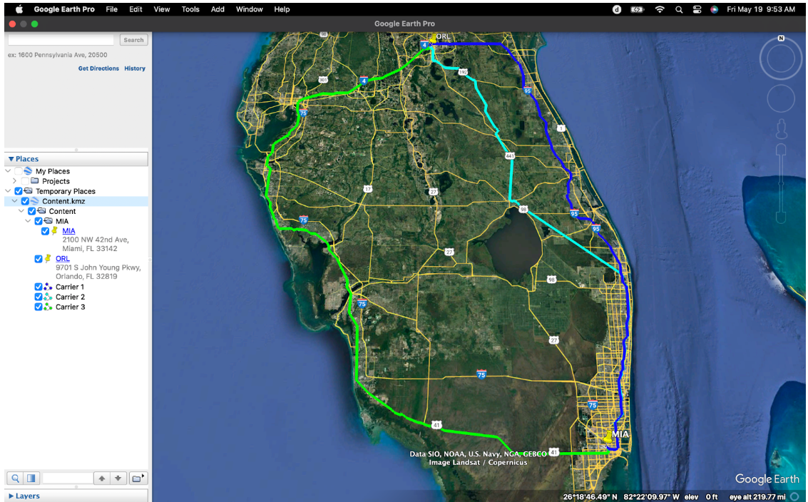
In the image above, three .kmz files have been obtained from providers, and combined to allow fiber routes to be assessed. The dark blue coastal route is the Primary, the light blue is carrier 2, and the green route is carrier 3, with carrier’s 2 and 3 considered as secondary routes.
From this birds-eye view, we can see that carrier two isn’t ideal – for at least a third of the route, it overlaps the primary route. Any outages along this route would affect both providers.
If we zoom in for a close-up of the Z LOC in Miami, we can see the problem that occurs time and time again when attempting to incorporate network diversity.
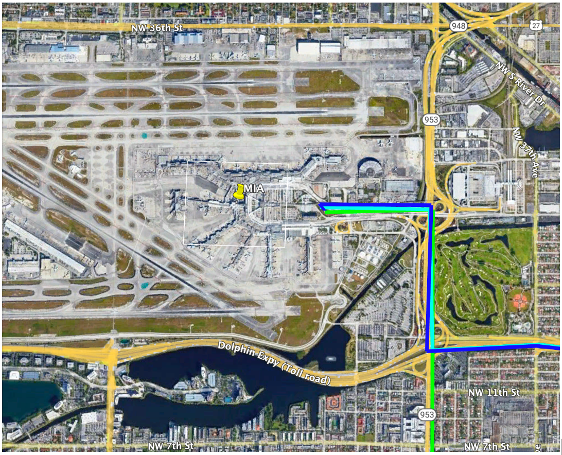
All three carriers leave the property via the same route and overlap for several hundred meters. It’s unlikely that alternative fiber routing could be arranged at this location, due to the complexity of the local infrastructure – as well as waterways, there are several active airport runways surrounding the property.
The A LOC .kmz shows a similar problem.
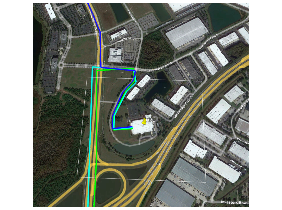
Here we can see additional possibilities, though – carrier 3’s approach could be shortened, crossing the field to terminate at the A LOC’s phone room without overlapping the Primary fiber route, which enters from the north.
As you can see, vetting potential fiber routes using .kmz files isn’t a difficult task. It can, however, be a time-consuming experience. Negotiating the release of these files before contracts are signed, and the administrative burden and expenses associated with asking carriers to provide additional diversity can be onerous.
Working with Lightyear’s telecom procurement operating system can remove a lot of the guesswork and research, and our dedicated industry professionals are on hand to help you reach effective decisions based on clear data. We can even do some of this .kmz map analysis for you!
Featured Articles
Want to learn more about how Lightyear can help you?
Let us show you the product and discuss specifics on how it might be helpful.
Stay up to date on our product, straight to your inbox every month.